The Saigon River is one of the most important rivers in southern Vietnam and is deeply connected with the formation and development of Ho Chi Minh City. Its waters do not merely flow through a major urban center. Over the centuries, the river has helped shape the region’s economic, commercial, transportation, cultural, and residential landscape.
For many centuries, the Saigon River served as a natural trade route linking the upstream areas of Tây Ninh and Bình Dương, the southeastern region, Gia Định, Saigon, Đồng Nai, the Mekong Delta, and the coastal waters of Cần Giờ. Before the development of roads, railways, and aviation, large-scale transportation depended heavily on boats, barges, and the dense network of rivers and canals.
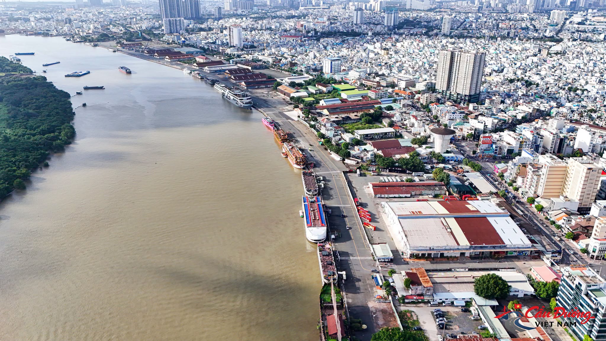
Today, the Saigon River remains an important hydrological, transportation, and landscape axis of Ho Chi Minh City. It passes through historic areas such as Bến Nghé, Thủ Ngữ, Nhà Bè, and Cát Lái, while also running alongside modern urban districts, high-rise buildings, seaports, financial centers, and spaces being planned as ecological corridors and riverside parks.
It can be said that the history of Saigon has always developed in parallel with the history of the Saigon River. The city grew from its waterfronts, cargo boats, riverside warehouses, and the continuous connections created by flowing water.
Where Does the Saigon River Begin, How Long Is It, and Where Does It End?
The Saigon River belongs to the Đồng Nai River system and originates in the region along the Vietnam–Cambodia border. Its upper reaches are generally associated with waterways in the Tonlé Chàm and Rạch Chàm areas, as well as the northern parts of Bình Phước, Hớn Quản, and Lộc Ninh. Depending on how the source and the extent of the river system are defined, different documents may provide slightly different figures for its total length.
According to figures commonly used in hydrological and planning documents, the Saigon River is approximately 251 kilometers long. Some studies that include the upstream streams, tributaries, and a broader watershed may estimate its length at around 250–280 kilometers. These differences mainly result from different methods of determining the river’s official starting point.
From its upper reaches, the river flows through Tây Ninh and Bình Dương before entering Ho Chi Minh City. Along its journey, it passes through a variety of landscapes, including low hills, agricultural land, reservoirs, industrial areas, and densely urbanized districts.
One major structure that has a significant influence on the river’s flow regime is Dầu Tiếng Reservoir, located within the Saigon River system in Tây Ninh Province. The reservoir plays an important role in storing and regulating water, supplying water for agriculture and production, and supplementing downstream flows during the dry season. Since the reservoir began operating, the hydrological conditions of the Saigon River have been noticeably influenced by its water-regulation activities.
Within Ho Chi Minh City, the Saigon River extends for approximately 80 kilometers. Its width varies considerably from one section to another. Some stretches are around 100–200 meters wide, while others expand to several hundred meters or even more near major confluences and downstream areas. Planning documents generally identify its average width as approximately 100–500 meters, while its typical depth ranges from 8–15 meters, with certain sections being deeper due to local geography, riverbed conditions, and dredging activities for inland waterway transportation.
The Saigon River does not flow directly into the sea under its own name. In the southeastern part of Ho Chi Minh City, it joins the Đồng Nai River in the area commonly known as Đèn Đỏ Junction, near Cát Lái. From this point onward, the combined waterway is known as the Nhà Bè River.
The Nhà Bè River then flows downstream and divides into two major routes: the Soài Rạp River and the Lòng Tàu River. The Soài Rạp River has a broad channel, although some sections are relatively shallow. The Lòng Tàu River has a deeper channel and plays a particularly important role in the maritime route connecting seagoing vessels from the coastal waters to the port system of Ho Chi Minh City.
Therefore, if the river is considered according to its main channel, the Saigon River ends at its confluence with the Đồng Nai River, where the Nhà Bè River begins. If its entire hydrological journey is considered, water from the Saigon River continues through the Nhà Bè, Soài Rạp, and Lòng Tàu systems before reaching the East Sea through Cần Giờ, Gành Rái Bay, and the coastal estuary.
The Saigon River and Its Connected Network of Rivers and Canals
The Saigon River does not exist as an isolated watercourse. It is connected to a dense network of rivers, streams, canals, and waterways throughout southeastern Vietnam. This network is one of the main reasons the river became such an important transportation and commercial axis throughout history.
In its upper and middle reaches, the river receives water from numerous waterways in Tây Ninh, Bình Dương, Củ Chi, and the northern areas of Ho Chi Minh City. As it enters the urban region, the waterway network becomes more complex, with the presence of Vàm Thuật Creek, Tra Creek, Láng The Creek, Bàu Nông Creek, and many other natural waterways. These creeks help drain water from agricultural and residential areas while also connecting inland communities with the main river.
Closer to the city center, the Saigon River is linked to many canals and waterways that have become inseparable from the history of the urban area. Cầu Bông Creek, Bến Nghé Creek, the Nhiêu Lộc–Thị Nghè water system, Tẻ Canal, Đôi Canal, Tàu Hũ Canal, Lò Gốm Creek, and numerous other waterways once extended deep into residential neighborhoods, markets, cargo terminals, and craft-production areas.
It is important to distinguish between natural tributaries and urban canals. Some waterways were formed naturally through geological and geomorphological processes, while others were excavated, redirected, widened, or improved over different historical periods to serve transportation, irrigation, and drainage purposes. Regardless of their origins, all of them contributed to the distinctive river-based urban structure of Saigon.
One particularly notable connection is Chiếc Creek, which links the Saigon River area with the Đồng Nai River system in the eastern part of the city. These creeks and interconnected canals transformed the Saigon–Gia Định region into an extensive inland waterway network, with the Saigon River serving as its main axis.
Downstream, after joining the Đồng Nai River, the water continues through the Nhà Bè River before dividing into the Soài Rạp and Lòng Tàu Rivers. This large-scale division has major implications for maritime transportation, drainage, tidal movement, and the development of the Cần Giờ coastal estuary.
From Prey Nokor to Saigon: The River in the Earliest Historical Layers
The history of the Saigon River is closely tied to the history of the Saigon–Gia Định region. However, its earliest milestones were not recorded only through wars and military campaigns. Official Nguyễn-era historical records often mentioned the southern territories in the context of warfare and the establishment of political control. In 1658, historical sources referred to the Mô Xoài area, now associated with Bà Rịa. By 1674, the name Saigon appeared more clearly in records concerning conflicts in the region.
Nevertheless, sources from Cambodia, accounts written by Western missionaries, and modern historical studies indicate that the Saigon area had already participated in regional trade before it became an administrative center under Vietnamese rule.
In 1623, the Nguyễn lords are believed to have sent a delegation to negotiate with King Chey Chettha II of Cambodia to establish tax-collection stations at Prey Nokor and Kas Krobei. Prey Nokor is commonly associated with the Saigon area, while Kas Krobei has been linked to the Bến Nghé region. This was a particularly important milestone because it demonstrates that the area was already part of a regional commercial and river-control network as early as the seventeenth century.
In that context, the Bến Nghé tax station would logically have been located at a position suitable for monitoring boats traveling along the major river. Some earlier theories placed it near Cầu Kho. However, if it had been situated too far inland, it would have been difficult to observe and control traffic moving along the main river channel. Another theory places the tax station near the present-day Thủ Ngữ Flagpole, where Bến Nghé Creek flows into the Saigon River and where river traffic could be monitored more effectively.
The name Thủ Ngữ, possibly related to the term “thủ ngự,” may have referred to a checkpoint or tax-control station rather than simply a military outpost. Its location was strategically important for both transportation and commerce, as boats from different directions had to pass through this area to reach Bến Nghé and the early Saigon marketplace.
In 1865, the French erected a flagpole on or near the site of the former station. Although the flagpole displayed different flags during different historical periods, local people continued to call it the Thủ Ngữ Flagpole. Unlike many place names that disappeared or survived only in the names of neighborhoods and waterways, Thủ Ngữ remained associated with a specific riverside location, preserving a trace of the region’s early commercial history.
From a riverside tax station, the Bến Nghé and Saigon area gradually developed into a center of settlement, trade, and river-based logistics. This also helps explain why, by 1698, when Nguyễn Hữu Cảnh arrived to establish an administrative foundation in Gia Định, the region already possessed a considerable population and economic capacity.
Historical records mention approximately 40,000 households at that time. Although the figure may not fully reflect the actual population, it indicates the existence of a strong economic foundation capable of supporting administrative institutions, military forces, and territorial management. Behind those figures lay a broad network of food supplies, boats, warehouses, handicraft production, and commerce in which the Saigon River played a central role.
“Busy Wharves and Boats Below”: The Formation of a Commercial City
When describing old Saigon, the expression “busy wharves and boats below” does not merely evoke a scene of crowded waterways. It reflects an organized river-based commercial system consisting of warehouses, landing stages, wholesale markets, craft workshops, and specialized trading districts.
Commercial activity along the Saigon River differed from the floating markets commonly seen in the Mekong Delta today. It was not simply a collection of small boats selling goods directly to consumers. Instead, it was a large-scale system for transporting, storing, distributing, and processing merchandise. Cargo boats from the Mekong and Bassac river basins carried local products, food, timber, firewood, bamboo, seafood, agricultural goods, and many other commodities to Saigon. From there, these goods were transferred to markets, warehouses, workshops, or other destinations.
Along Bến Nghé Creek and the waterways connected to the Saigon River, many place names emerged from the particular goods or economic activities associated with each area. Names such as Bến Sỏi Lò Vôi, Bè Tre, Chợ Đũi, Chợ Vải, Lò Heo, Xóm Chiếu, Xóm Củi, Xóm Dầu, Xóm Chỉ, Mễ Cốc, Cầu Đường, Lò Rèn, and Lò Gốm reveal a relatively clear specialization of commercial activities.
Each area was once associated with a particular category of goods or type of production. Some places specialized in timber and bamboo, others in textiles, firewood, oil, construction materials, livestock, ceramics, or handicrafts. These humble place names are actually traces of a commercial city organized according to different industries, with waterways serving as its economic lifeline.
Merchant vessels arriving from coastal areas brought goods from distant regions. Cargo boats from the Mekong Delta transported agricultural products upstream. Riverside warehouses received, sorted, and redistributed the goods. Around this activity, numerous supporting services emerged, including eateries, resting places, inns, boat-repair facilities, and suppliers of fresh water, food, ropes, timber, oil, and other necessities for river journeys.
The Saigon River therefore did more than transport goods. It supported an entire riverside economic ecosystem. The city developed from the practical needs of merchants, boatmen, craftsmen, warehouse operators, and communities whose livelihoods depended on the waterfront.
Các Lái, Xóm Quán, and the Traces of Long-Distance Trade
The Các Lái area, now commonly associated with Cát Lái, is a place name that clearly reflects long-distance commercial activity along the Saigon and Đồng Nai River systems. The 1836 Biên Hòa land register recorded “Hưng Thạnh Village in the area of Các Lái.” This was likely a place where merchants and boat owners could gather their goods, wait for favorable tides, or remain in place until weather and wind conditions improved.
Opposite the Các Lái area, two warehouses known as Tân Thạnh and Cảnh Dương reportedly existed during the Nguyễn lords’ period. Historical materials indicate that these warehouses stored a substantial portion of the taxes collected in Gia Định before they were transported to Thuận Hóa. This demonstrates that riverside warehouses served not only merchants but also played an important role in the financial, logistical, and administrative systems of the authorities.
In earlier times, long-distance commercial journeys could not be completed as quickly as they can today. Boats depended on seasonal winds, tides, weather, and navigational conditions. Some merchants had to remain in one location for several months while waiting for a suitable departure time. Temporary settlements, resting places, repair facilities, and trading points gradually developed into neighborhoods, wharves, and place names that survived for generations.
In the downstream region, the name Xóm Quán was also associated with long-distance merchants and sailors. In 1835, during the reign of Emperor Minh Mạng, four merchant vessels from Qing China arrived at the Cần Giờ estuary in Gia Định. The court allowed them to trade near the Tam Kỳ River but restricted their movement ashore and required them to depart within approximately four to five months.
At that time, the Tam Kỳ River was associated with the area around the Lòng Tàu junction today. As merchants and sailors gathered there, the need for food, accommodation, boat repairs, and trading opportunities encouraged the growth of small eateries and informal services. The area gradually became known as Xóm Quán and appeared on a French map from 1881 under the name “Song Xom Quan.”
A traditional boatmen’s verse has been preserved:
“Here lie Bình Đông and Xóm Chỉ,
Rowing to Xóm Quán takes less than one watch of the night.”
The verse not only suggests the short distance between the locations by water but also indicates that Xóm Quán was once a gathering point for goods and an important link in the riverside transportation network. Place names such as Các Lái, Xóm Quán, and Thủ Ngữ were not accidental names. They are surviving memories of a period when commerce was governed by the rhythm of the tides.
Nhà Bè and the Culture of River Travel
Within the southern river system, Nhà Bè is well known for its location at a major confluence and river division. A traditional verse says:
“At Nhà Bè the waters divide in two,
One heads to Gia Định, the other toward Đồng Nai.”
The verse appears in historical sources in forms that differ slightly from the version commonly circulated in folk tradition today. It reflects the geographical position of Nhà Bè, where waterways divide and boats can travel toward either Gia Định or Đồng Nai.
However, Nhà Bè was important not only because of its position at a water junction. In the past, tides rose and fell twice a day, making boat travel heavily dependent on the movement of the water. Boats traveling upstream or carrying heavy cargo often had to stop and wait for a favorable tide. This condition created a need for natural resting points along the river.
Folk accounts tell of a wealthy man named Thủ Huờn, who built a bamboo floating house equipped with rooms, cooking facilities, rice, and food that travelers could use free of charge. Merchants and passengers who missed the tide could stop to rest without having to pay.
This story reflects an important aspect of southern Vietnam’s river culture: commerce was not based solely on buying and selling but also encouraged forms of community support. Along waterways where the tide determined the rhythm of travel, a resting place, a floating house, or a riverside cooking fire could be extremely valuable to travelers.
Today, Nhà Bè has become a rapidly developing urban area. Yet its name and memories of floating houses, ferry crossings, and divided waterways still evoke a time when river transportation occupied a central position in southern life.
The French and the Establishment of the Name “Saigon River”
Before the French period, different sections of the river were often known by various local names. Upper, middle, and lower sections, as well as areas near specific creeks and landing points, could have their own names depending on local usage.
During the French period, as surveying, mapping, and colonial administration expanded, the river began to be identified as a unified hydrological system. The map Cochinchine Française, Expedition de 1858 was among the early documents to use the designation “R. de Saigon,” meaning Saigon River, to describe the waterway extending from the Tonlé Chàm upstream area to the Soài Rạp estuary.
The establishment of a unified name was important for the geographical history of the river. Sections previously identified by local names were incorporated into one recognized waterway on administrative, military, and maritime maps. From that point onward, the Saigon River became a clearly defined geographical entity in the management and planning of Cochinchina.
As Saigon was developed according to the model of a colonial city, the river became one of the city’s natural boundaries. Thị Nghè Creek, the Saigon River, Bến Nghé Creek, and the canal network to the west together shaped the geographical structure of the earliest urban center.
This demonstrates that early Saigon was not a city formed separately from its waterways. On the contrary, the city was shaped by water. The Saigon River functioned simultaneously as a boundary, a transportation route, a commercial space, and a gateway connecting Saigon with the outside world.
The Saigon River during the Port-City Era and Modern Urban Development
From the nineteenth into the twentieth century, the port and wharf system along the Saigon River expanded considerably. Saigon Port, cargo terminals, foreign-trade warehouses, ship-repair workshops, and inland waterway transportation helped the city become an important international commercial center of Indochina.
Saigon’s economic strength came from its ability to connect multiple directions. From the river, goods could travel toward Tây Ninh, Bình Dương, Đồng Nai, the Mekong Delta, or the coastal waters of Cần Giờ. Conversely, products from manufacturing regions, the delta provinces, and international maritime routes could be concentrated in the city’s port, warehouse, and wholesale-market systems.
The Saigon River is directly connected to the Đồng Nai River, Nhà Bè River, Soài Rạp River, and Lòng Tàu River. As a result, Saigon was never simply a city located beside one river. It was positioned at the center of an extensive interregional waterway network.
As roads, railways, and aviation developed, the river’s role in passenger transportation gradually declined. Nevertheless, cargo transportation, port operations, water supply, drainage, and urban scenery have continued to make the Saigon River indispensable.
During rapid urbanization, many sections of the riverbanks and canals were encroached upon, polluted, or narrowed. Some waterways were transformed into urban drainage channels, while many riverside areas gradually lost their public spaces. A river that had once been closely integrated into everyday life became increasingly separated from the city by roads, buildings, and enclosed urban developments.
In recent years, however, the perception of the Saigon River has begun to change. The river is increasingly viewed as a strategic urban asset, not only for transportation but also for landscape design, ecology, culture, tourism, and quality of life.
Potential for Inland Waterway Transportation and Logistics
The Saigon River enjoys a particularly advantageous position between the most densely urbanized area in southern Vietnam and the extensive production network of the southeastern region. It connects industrial zones in Bình Dương, Tây Ninh, and Đồng Nai with the port system of Ho Chi Minh City and the coastal estuaries.
Through the Saigon River, goods can reach the Cát Lái–Phú Hữu port area, Nhà Bè, Hiệp Phước, the Soài Rạp River, and farther toward the Cái Mép–Thị Vải port complex and the planned international transshipment port in Cần Giờ. This corridor has major significance for import-export activities, logistics, and multimodal transportation.
Inland waterways are particularly suitable for transporting large volumes of cargo, bulk goods, construction materials, agricultural products, containers, and commodities that do not require extremely rapid delivery. At a time when roads are under constant pressure from congestion and logistics costs continue to rise, developing waterway transportation could help reduce the burden on land-based transport while lowering fuel consumption and emissions.
However, fully exploiting this advantage requires seamless connections among inland waterway terminals, seaports, warehouses, logistics centers, roads, and railways. The Saigon River can only realize its full potential when it forms part of an integrated transportation system rather than being developed through isolated port projects.
Potential for River Tourism and Urban Landscapes
One of the Saigon River’s most outstanding values is its scenery. Few major cities possess such a broad, winding river passing through the urban center, historic districts, modern architectural landmarks, peninsulas, islets, suburban areas, and ecological landscapes.
The Saigon River could support a wide range of distinctive tourism products, including sightseeing cruises through the city center, waterbus routes connecting Bạch Đằng with Thủ Thiêm, Bình Quới, and Củ Chi, heritage journeys exploring the history of the port city, dining cruises, sunset excursions, visits to riverside craft villages, and routes connecting with the Đồng Nai River, Nhà Bè, and Cần Giờ.
A river journey can take visitors through several contrasting landscapes. From high-rise buildings and financial centers in the downtown area, boats can travel toward Thủ Thiêm, Thanh Đa, and Bình Quới, pass riverside residential communities and suburban districts, move through agricultural areas, and eventually connect with estuarine ecosystems, mangrove forests, and the sea at Cần Giờ.
This is one of Ho Chi Minh City’s distinctive advantages. Within a single waterway journey, visitors can experience the transition from a modern metropolis to rural landscapes and from a historic port city to a coastal ecological environment.
With appropriate planning, both banks of the Saigon River could be developed into a chain of riverside parks, public squares, pedestrian areas, tourist piers, community cultural spaces, restaurants, heritage interpretation centers, and riverside cycling routes. In that case, the river would no longer be viewed only from bridges or high-rise buildings but would become a genuine public space for residents.
The Saigon River and Its Environmental Challenges
Despite its considerable potential, the Saigon River is under increasing pressure from urbanization and economic development. Its watershed encompasses densely populated neighborhoods, industrial zones, agricultural areas, and major transportation routes. Domestic wastewater, industrial discharge, solid waste, construction activities, and surface runoff can all affect water quality.
Creeks flowing into the river, particularly in urban areas, may carry wastewater and solid waste from residential communities. When these waterways are narrowed, encroached upon, or lose their natural self-cleaning capacity, pollution can spread into the main river.
Another major challenge is flooding. The Saigon River is affected simultaneously by heavy rainfall, high tides, land subsidence, water flowing from urban drainage basins, and changes in the drainage system. When heavy rain coincides with high tides, the risk of flooding increases in low-lying areas along the river and canals.
Climate change is also bringing sea-level rise, extreme weather, and increasingly irregular heavy rainfall into long-term planning considerations. Riverside development therefore cannot focus solely on real estate value or visual appeal. It must preserve sufficient space for water flow, water-retention areas, flood-discharge corridors, and natural ecological zones.
Protecting the Saigon River requires a combination of measures, including wastewater control, stronger water-quality monitoring, restoration of waterways, restrictions on riverside encroachment, protection of hydrological corridors, development of wetland parks, and water-regulation systems adapted to tidal conditions.
The Saigon River in the Future of Ho Chi Minh City
In long-term planning orientations, the Saigon River is regarded as a major development axis of Ho Chi Minh City. The areas along both riverbanks, especially in the central districts, Thủ Thiêm, and suburban zones, are being considered for development as landscape, ecological, cultural, and urban-service corridors.
The river can perform several roles simultaneously. It can serve as an inland transportation route for cargo and tourism, a landscape axis that gives the city its identity, an ecological corridor that helps regulate the urban climate, a public space for residents, and a connecting route between the region’s economic centers.
Within a green-and-blue development structure, the Saigon River should be linked with the Đồng Nai River, Nhà Bè River, Soài Rạp River, Lòng Tàu River, Thị Vải River, Dầu Tiếng Reservoir, and the Cần Giờ mangrove ecosystem. Together, these form an interconnected natural system that regulates water, protects biodiversity, reduces flooding, mitigates the urban heat-island effect, and strengthens the city’s ability to adapt to climate change.
If properly managed and developed, the Saigon River could become one of the most valuable urban assets of Ho Chi Minh City. Its importance lies not only in its approximate length of 251 kilometers, its hundreds-of-meters-wide channel, or its role in inland transportation, but also in the dense historical memory accumulated along its banks over many centuries.
That memory includes the Bến Nghé tax station, the Thủ Ngữ Flagpole, cargo boats arriving from the Mekong Delta, specialized trading areas such as Xóm Củi, Xóm Dầu, and Lò Gốm, as well as Các Lái, Xóm Quán, Nhà Bè, and the warehouses that once sustained an entire city. It also includes merchants waiting for the tide, floating houses along the river, ferry crossings, and communities whose lives depended on the water.
The Saigon River has passed through many periods of transformation. It was once an early trade route, later became the lifeline of a colonial port city, and subsequently witnessed industrialization, urbanization, and the emergence of a modern metropolis. Some sections of the river were neglected for a time, while others are now being revitalized through riverside parks, piers, waterway tourism, and public-space planning.
The river does not merely flow through the city. In a deeper sense, the Saigon River helped create the city itself.
General Information about the Saigon River
- Vietnamese name: Sông Sài Gòn
- English name: Saigon River
- River system: Đồng Nai River Basin
- Source: The Tonlé Chàm and Rạch Chàm areas, the Vietnam–Cambodia border region, and the Hớn Quản and Lộc Ninh areas, depending on the method of identification
- Length: Approximately 251 km according to Ho Chi Minh City planning descriptions; some studies that include the entire watershed and upstream sections estimate approximately 250–280 km
- Average width: Approximately 100–500 m
- Typical depth: Approximately 8–15 m; some sections within Ho Chi Minh City may be deeper
- Related localities: Cambodia’s border region, Bình Phước, Tây Ninh, Bình Dương, and Ho Chi Minh City
- Length within Ho Chi Minh City: Approximately 80 km
- Confluence: Joins the Đồng Nai River near Đèn Đỏ Junction, close to Cát Lái
- Name after the confluence: Nhà Bè River
- Main routes toward the sea: Soài Rạp River and Lòng Tàu River
- Outlet to the sea: Cần Giờ, Gành Rái Bay, and the East Sea
- Main roles: Inland waterway transportation, logistics, water supply, drainage, urban landscape, tourism, ecology, and history
- Historic areas associated with the river: Bến Nghé, Thủ Ngữ, the Thủ Ngữ Flagpole, Nhà Bè, Các Lái, Cát Lái, Xóm Quán, and Saigon Port
- Future development orientation: Green-and-blue corridors, riverside parks, waterway tourism, inland transportation, logistics, ecological restoration, and climate-change adaptation