


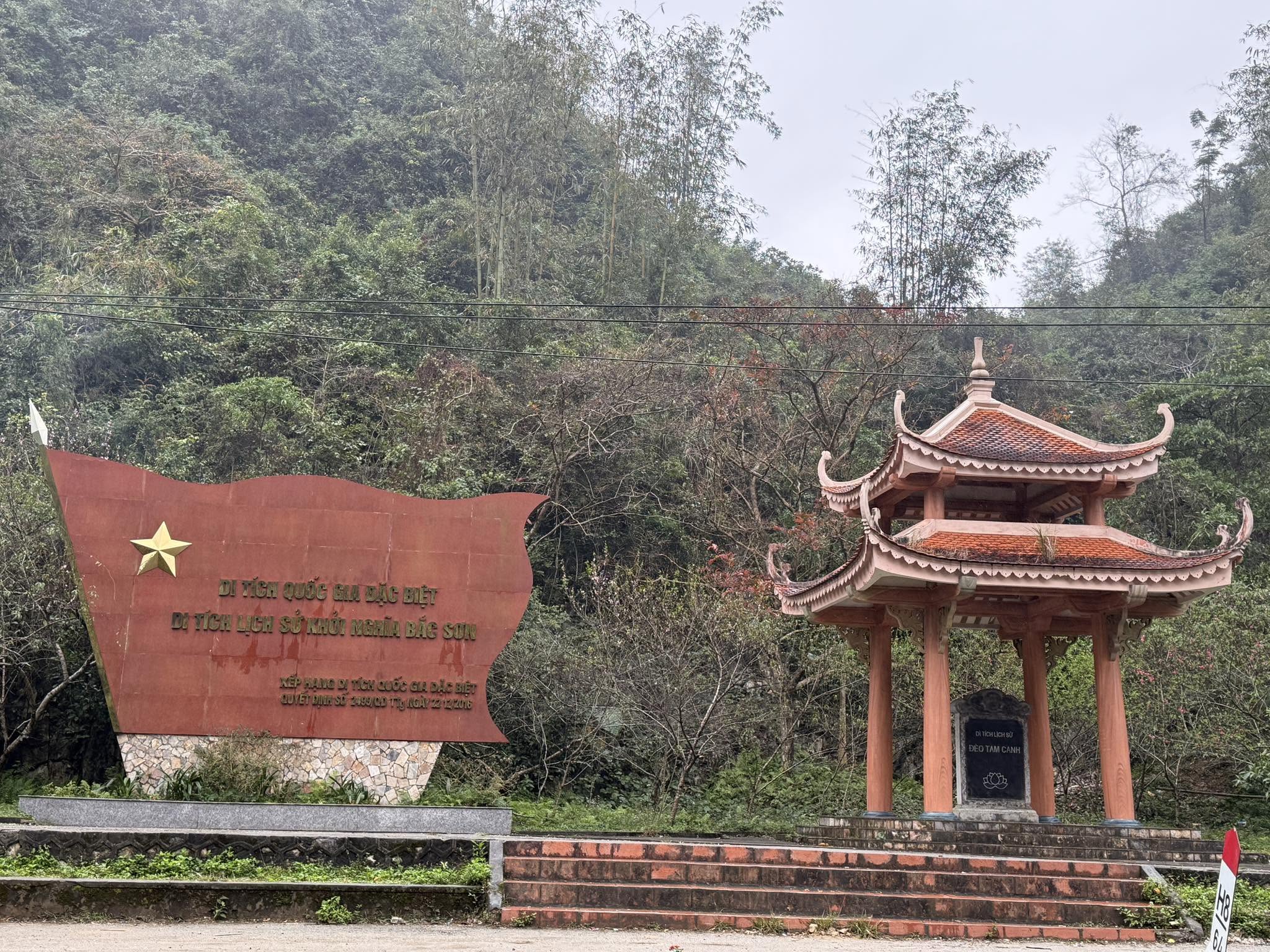
The Bac Son Uprising Historical Site is a particularly significant complex of revolutionary military and historical relics in Vietnam. It preserves important events associated with the formation and development of the revolutionary movement in Bac Son, from the early dissemination of revolutionary ideology and establishment of Party organizations to the Bac Son Uprising in 1940, the formation of the guerrilla base, the Cuu Quoc Quan forces, and the preparations for the General Uprising to seize power in 1945.
Major historical events associated with the site include the introduction of revolutionary ideology and establishment of the first Party cell in Bac Son during the period 1930–1936; the movement for civil rights and democratic freedoms and the establishment of the Bac Son District Party Committee from 1936 to 1939; the Bac Son Uprising on September 27, 1940, which marked the beginning of a new wave of revolutionary struggle throughout the country; the establishment of the Bac Son Guerrilla Base on October 16, 1940; the formation of the Viet Minh Front and the development of revolutionary forces between 1941 and 1945; the establishment of the Bac Son Cuu Quoc Quan unit in the Bac Son–Vo Nhai revolutionary base in February 1941; and the anti-Japanese national salvation movement and the uprising to seize power in 1945.
During the revolutionary period, Bac Son also served as a secure base for sheltering and protecting senior Party and revolutionary cadres from the Central Party organs and the Northern Regional Party Committee. It was an important communications station linking the Central Party with the Northern Regional Party Committee and other revolutionary areas, while also supplying documents for the training of revolutionary cadres.
The site consists of 12 locations, distributed across six communes, namely Tan Huong, Hung Vu, Vu Lang, Vu Le, Tan Lap, and Long Dong in Bac Son District, Lang Son Province. It was first recognized as a national historical relic in 1992.
The Main Sites of the Bac Son Uprising Historical Complex
Bo Tat Site, also known as Mo Tat, covers an area of 15,798 square meters. The location is now largely in ruins, with only the foundation of the former house belonging to Duong Van Thong remaining, covering approximately 54 square meters, together with several stones that once supported the house pillars. The former residential area is surrounded by fruit trees and clumps of thorny bamboo.
Na Kheo Hill Site covers 4,463 square meters and is situated on the top of a high hill surrounded by rice fields, bamboo groves, dense vegetation, and several residential houses. At the foot of the hill is a trench system approximately 30 meters long, about 1 meter high, and 0.5 meters wide, associated with the defensive arrangements used to protect the revolutionary area.
Nong Luc Communal House is located to the north of Provincial Road 241. Two large banyan trees, estimated to be around 100 years old, stand on either side of the building. Constructed during the Nguyen Dynasty on a raised mound, the communal house covers a total area of 182.7 square meters. It features a traditional wooden stilt-house structure, with the floor raised approximately 0.7 meters above ground level, a tiled roof, and wooden-panel walls on all four sides. The communal house is dedicated to Cao Son Quy Minh. Its wooden architectural elements feature elaborate carvings depicting traditional motifs such as the four sacred animals, paired dragons among clouds, paired dragons facing the sun, mythical nghê creatures, and floral patterns.
Mo Nhai Fort Site occupies a hill of more than 78,000 square meters, overlooking the route from Bac Son Town to Tran Yen and Vu Lang communes. The French colonial authorities once built a fortified post and permanent structures on the hilltop. The fort was surrounded by a rubble-stone wall nearly 40 centimeters thick and dense barbed-wire fencing. The only road from the foot of the hill to the fort was approximately 6 meters wide. Today, the remaining traces consist of two rectangular stone foundations, approximately 1.5 meters high and 0.6 meters thick. About 100 meters from the former fort foundations, on the northern side of the hilltop, stands a monument commemorating the victory at Mo Nhai Fort. A commemorative stele has also been erected near the provincial road at the foot of the hill.
Tham Thoong–Dap Di Site is a section of mountain pass along Provincial Road 241, on the Bac Son–Vu Lang route, covering 2,647 square meters. The historical event took place along a roughly 500-meter section in the middle of the pass, within Vu Lang Commune. A commemorative sign has been installed beside the road marking the location.
Vu Lang School Site covers 844 square meters. Its northwestern side borders an inter-village concrete road and Vu Lang Lower Secondary School. The site is enclosed by brick walls and landscaped with flowers and ornamental plants. It contains a commemorative stele and the former Vu Lang School building, a three-room, single-storey structure covering 102 square meters, built by the French colonial authorities in 1927. The building has been repaired and converted into a traditional exhibition house introducing the revolutionary history of Bac Son.
Sa Khao Site, also known as Phia Khao, is located in the Sa Khao valley and covers 2,626 square meters. It is surrounded by Sa Khao Mountain and Po Nen Mountain, at an average elevation of 500–550 meters above sea level. The site was once associated with the house of Ly Van Tinh, the father of Ly Thi Quyen, where Central Party cadres and members of the Bac Son District Party Committee were sheltered during their revolutionary activities. The original house has become a ruin, with only its earthen foundation remaining. The foundation measures 67.5 square meters, approximately 9 meters long and 7.5 meters wide, facing southeast. Descendants of the family have reconstructed a two-storey stilt house made of bamboo and other natural materials on the original foundation, covering about 30 square meters. To the left of the house is a fishpond of approximately 300 square meters, which was formerly used to raise fish as food supplies for revolutionary cadres. A family garden lies to the right. A commemorative stele has been erected at the entrance to the site.
Khuoi Noi Site lies within the Tam Tau forest and covers 33,151 square meters. It is surrounded by high mountain ranges and rich, diverse vegetation. This was a secret operational area of the Cuu Quoc Quan. In the event of danger, the force could retreat safely in several directions. To the south, they could cross into Phu Thuong Commune in Vo Nhai District; to the east, they could move through the forest toward Tan Thanh and Tan Huong communes in Bac Son District. The site retains locations where camps and training grounds of the Cuu Quoc Quan were once established. In 2014, several facilities were constructed, including a guard post, two camp structures consisting of a command hut and a living hut for members of the unit, a commemorative symbolic monument, a landscaped area, and a ceremonial platform.
Lan Pan Site covers 11,000 square meters and is situated on the slope of Pac Ca limestone mountain, at an average elevation of approximately 500 meters above sea level. The area is surrounded by mountain slopes and fruit gardens belonging to local residents. The location associated with the historical event is a rocky area of approximately 100 square meters, surrounded by jagged limestone formations 40–80 centimeters high and a natural rock shelter approximately 7 meters high. From this position, a broad view can be obtained over the Lan Pan fields and the inter-commune road connecting Huu Vinh, Tan Lap, and Tan Huong. Lan Pan was a secret operational location of a Central Party delegation during the implementation of the Central Resolution No. 8 and the consolidation and development of local armed forces within the Bac Son Party organization. A commemorative stele has been erected approximately 500 meters from the site.
Lan Tay–Mo Pia Site covers more than 24 hectares and consists of two locations, Mo Pia Cave and Lan Tay.
Mo Pia Cave is located in the southern part of the complex. It is a limestone cave covering approximately 3,000 square meters, with an entrance 7 meters high and 4 meters wide.
Lan Tay lies in the northern part of the complex and was the location where a senior Central Party delegation established a temporary rest camp. The area contains numerous rocky clearings and patches of land surrounded by small, successive limestone mountains with average elevations of 600–700 meters above sea level. These formations create a basin-like area covering more than 1 hectare. Its rugged terrain, relatively convenient access, fresh climate, extensive land, dense vegetation, and sparse population made Lan Tay a suitable location for secret revolutionary activities and safe withdrawal during periods of danger.
Mo Re Cave Site covers 9,304 square meters and is located within Mo Re Mountain, which covers 38,608 square meters and has an average elevation of approximately 480 meters above sea level. A flooded area lies at the foot of the mountain, surrounded by local fields and gardens. The cave is situated halfway up the mountain, facing northwest. The route to and from the cave is difficult, while vegetation conceals the entrance from view. Mo Re Cave was a secret operational base for leaders of the Northern Regional Party Committee and the site of a fierce battle to break through an enemy encirclement on August 28, 1941.
Tam Canh Pass Site is located along National Highway 1B, which connects Binh Gia and Bac Son districts, within Long Dong Commune. The pass is nearly 4 kilometers long, with an average elevation of 450–480 meters above sea level. It is surrounded by limestone mountains ranging from 550 to 650 meters in elevation and covered with dense vegetation. The summit of Tam Canh Pass has been selected for the construction of a symbolic monument commemorating the Bac Son Uprising and a commemorative stele house. The total landscaped area covers approximately 120 square meters.
Historical Significance and Conservation
Documents and artifacts associated with the Bac Son Uprising Historical Site are currently preserved, managed, and displayed at the Bac Son Museum and the Traditional Exhibition House at Vu Lang School. The collection consists of 138 objects, including 127 original artifacts and 11 reconstructed items. These materials help illustrate the formation of Party organizations, the activities of revolutionary cadres, the development of armed forces, and the major events associated with the Bac Son revolutionary movement.
The Bac Son Uprising holds profound significance in Vietnam’s national history. It represents the patriotism, determination, resilience, and fighting spirit of the people of Bac Son, as well as the broader Vietnamese revolutionary movement. The uprising was an important milestone in the development of the struggle for national liberation and contributed to the preparation of revolutionary forces, experience, and bases for the later struggle to regain national independence.
Today, the historical sites, revolutionary events, festivals, and traditional customs associated with the Bac Son Uprising Historical Complex form a valuable body of tangible and intangible cultural heritage. Their preservation, restoration, and promotion contribute to historical education, the cultivation of patriotic traditions, the development of cultural tourism, and the sustainable socio-economic development of the locality.
Recognizing its particularly outstanding historical value, the Bac Son Uprising Historical Site in Bac Son District, Lang Son Province, was designated a Special National Monument by the Prime Minister under Decision No. 2499/QD-TTg dated December 22, 2016.


